The Lane Farm Development and the Bypass-Driven Growth in Lucketts
12/4/2025
For years, Lucketts residents have heard conflicting messages about Route 15, the long-debated “Western Bypass,” and whether major development would follow any expansion. Now, the question is no longer hypothetical.
A formal application has been submitted to Loudoun County’s Department of Building and Development for a 67-house subdivision on the 334-acre Lane Farm property—and the developer’s own documents explicitly show that the project depends on construction of a new western Route 15 bypass.
This is the first large-scale residential plan filed in Lucketts that openly relies on a bypass to proceed. And it likely will not be the last.
Where Is This Development?
The Lane Farm residential project is located at 14678 New Valley Church Road in Loudoun County. The property contains roughly 334 acres, zoned AR-1 (Agricultural Rural–1) and currently used as active farmland with open fields on gentler slopes and wooded areas around the perimeter.
Surrounding properties are a mix of agricultural and rural residential uses.
According to the applicant’s project narrative, the site:
- Lies within the Limestone Overlay District (LOD) and Mountainside Overlay District (MOD)
- Contains a mapped FEMA floodplain
- Includes Prime Farmland Soils
- Fronts multiple rural roads: New Valley Church Rd, Stumptown Rd, Montresor Rd, and James Monroe Hwy
- Is anticipated to be traversed by the Route 15 Bypass, with land dedication expected
Read the full Project Narrative (PDF)
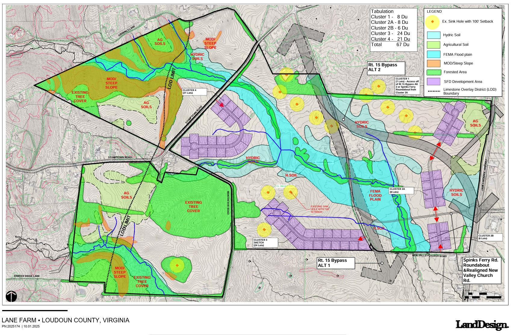
Lane Farm Concept Plan
How the Site Plan Is Laid Out
The concept plan prepared for Lane Farm shows five residential clusters totaling 67 single-family detached homes, designed under the AR-1 cluster subdivision option.
Key elements visible on the concept plan:
- Five clusters of residential lots:
- Cluster 1 – 8 lots
- Cluster 2A – 8 lots
- Cluster 2B – 6 lots
- Cluster 3 – 24 lots
- Cluster 4 – 21 lots
- Overlay data including:
- Prime agricultural soils
- Hydric soils
- Steep and moderately steep slopes
- FEMA floodplain
- Sinkholes with 100-foot buffers
- LOD boundary
- Bypass Alternative 1 and Alternative 2 drawn directly across the property
- Cluster 1 is explicitly accessed via the bypass or the Spinks Ferry roundabout
What the County’s Pre-Meeting Summary Says
Loudoun County’s Pre-Application Summary for case PMTG-2025-0220 confirms:
- 338 acres across two parcels
- 67 proposed lots under AR-1 Cluster Option
- 30.09 acres Prime Farmland Soils
- 70% of site (~236 acres) must be in preserved/agricultural/open space uses
- Property contains LOD, MOD, steep slopes, RSCR, FOD
- Requires:
- Special Exception (MOD subdivision)
- Preliminary Soils Report
- Geophysical/karst study
- Hydrogeologic study
- Phase I archaeology + cemetery reconnaissance
- Floodplain study
- Wetlands delineation
- Community water/wastewater system review
Read the County Pre-Meeting Summary (PDF)
Status in LandMARC: Pre-Meeting Complete
The LandMARC record for Plan Number PMTG-2025-0220 shows the Lane Farm premeeting as 100% complete, with all workflow steps passed:
- Application Completeness Check
- Premeeting Review
- Schedule & Hold Premeeting
- Store & Record Documents
- Close Case
Completion Date: 12/01/2025
Fees: $0
This confirms Lane Farm has officially entered the County’s development pipeline.
The Bypass as a Design Assumption
The project narrative states:
“The proposed Route 15 bypass is anticipated to traverse the parcel…”
The developer treats the bypass as a given, not a hypothetical.
The concept plan depends on:
- Route 15 Bypass (Alt 1 & Alt 2)
- Spinks Ferry Rd roundabout
- Realigned New Valley Church Rd
County DTCI notes indicate a recommended bypass alignment will be presented to the Board of Supervisors in February 2026.
This means developers are already drafting subdivision plans based on a bypass before the public sees the final alignment.
The Impact of Bypass Option 1: Home Demolitions and New Development Access
The County’s currently preferred alignment—Bypass Option 1—comes with major consequences for existing residents that have not been clearly communicated.
According to County mapping and alignment drawings, Option 1 will require the demolition of approximately 8–12 existing homes along the corridor. These are not hypothetical impacts; they involve the displacement of families who currently live on the land the County proposes to take.
What is especially concerning is that the same alignment that destroys existing homes also creates direct new access for the proposed Lane Farm subdivision. As the concept plan shows, Bypass Option 1:
- Cuts directly through the Lane Farm property
- Aligns with the internal subdivision road network
- Provides primary access for Cluster 1 and secondary access routes for other clusters
- Is drawn into the developer’s engineering documents despite not being finalized publicly
In short:
Bypass Option 1 removes existing homes while enabling new homes to be built.
The County has emphasized congestion and safety as the rationale for the bypass, but the Lane Farm materials reveal a second, less stated driver: the bypass functions as required infrastructure for new development.
A Broader Pattern Along Route 15
Lane Farm fits into a larger surge of development interest along the Route 15 corridor:
- 20-home Toll Brothers project (Evans Pond Rd)
- 37-home subdivision (Spinks Ferry Rd)
- Multiple “farm preservation lots” on steep wooded slopes
- 104-acre parcel north of Lucketts (Bright Futures PM&D LLC)
Since 2017, farmland acquisitions by LLCs have accelerated.
The pattern resembles:
Build bypass → unlock developable land → build subdivisions → increase traffic → justify more widening.
What This Means for Lucketts
If the bypass proceeds:
- Farmland becomes bypass-served subdivision land
- Cluster development scales up
- Traffic volumes rise rather than fall
- Rural character erodes incrementally
And critically:
- By the time the bypass alignment is finalized, development plans based on it will already exist.
Lane Farm is Exhibit A.
What Residents Can Still Do
Residents can still influence the outcome:
- Submit comments on the bypass alignment
- Attend Planning Commission & BOS meetings
- Request a moratorium on bypass-dependent subdivisions
- Demand traffic modeling that includes induced demand
- Support conservation easements
- Ask elected officials direct questions about development impacts
Silence will be interpreted as consent.
If the community wants to preserve rural Lucketts, now is the time to speak up.
The developers have already built their plans and they are counting on the County to build the road that makes those plans possible.